Results 1 to 5 of 5

Thread: DNR hosts informational meeting on Keweenaw ORV trail designation April 17 in Eagle R

Hybrid View

Previous Post Previous Post   Next Post Next Post
  1. #1
    GLFWDA Member GLFWDA Member Trail_Fanatic's Avatar
    Join Date
    May 2006
    Location
    Muskegon and Oceana Counties
    Posts
    2,170
    Blog Entries
    4

    Default DNR hosts informational meeting on Keweenaw ORV trail designation April 17 in Eagle R

    FOR IMMEDIATE RELEASE
    March 29, 2012
    Contact: Rob Katona, 90-228-6561 or Debbie Munson Badini, 906-226-1352

    DNR hosts informational meeting on Keweenaw ORV trail designation April 17 in Eagle River

    The Department of Natural Resources will host an informational meeting on Tuesday, April 17, regarding the proposed designation of the Keweenaw ORV trail in Keweenaw County as a state off-road vehicle trail.

    The meeting will take place at 6:30 p.m. at the Houghton Township Community Building, located at 5059 4th St., Eagle River.

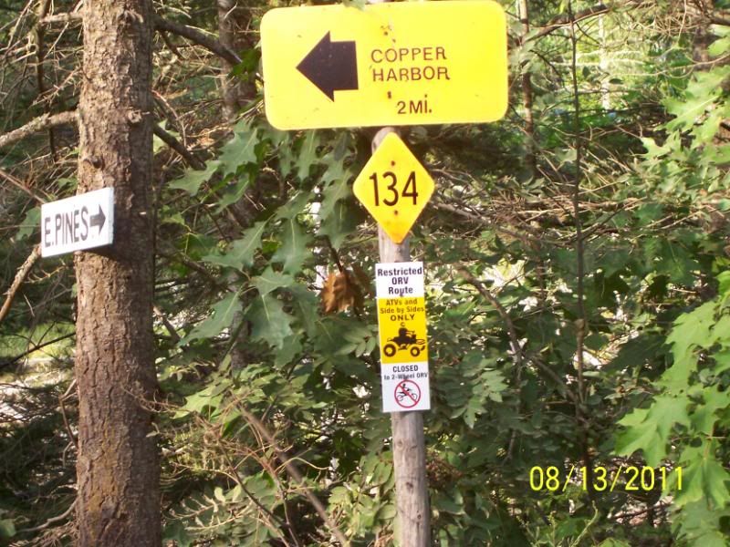
    The Keweenaw ORV trail would connect the state-designated Houghton-Calumet ORV Route to Copper Harbor by utilizing landowner permits to operate on private land. Due to special conditions requested by the private landowners on 54 miles of trail, designation of the trail as an official state ORV trail is contingent on a Land Use Order of the Director permitting those special conditions.

    Special conditions requested by the private landowners would prohibit the operation of certain types of ORVs and establish a seasonal period of operation.

    Designation as a state ORV trail would allow both the Keweenaw County Sheriff’s Department to apply for state ORV program law enforcement grants, and the Keweenaw ATV Club to apply for trail maintenance funding.

    “We are hosting this meeting to answer any questions and take public comment on the proposed special conditions necessary to accommodate the landowners who are otherwise supportive of this ORV trail,” said Rob Katona, DNR ORV trails analyst. “DNR Director Rodney Stokes will consider this public input when deciding whether to grant the Land Use Order.”

    For more information about the proposed state ORV trail designation and land use conditions, contact Rob Katona at 906-228-6561. Persons with disabilities needing accommodations for this public meeting should contact Katona a minimum of five business days before the meeting.

    To learn more about Michigan’s ORV trail and route system, go to www.michigan.gov/orvtrails.

    The Michigan Department of Natural Resources is committed to the conservation, protection, management, use and enjoyment of the state's natural and cultural resources for current and future generations. For more information, go to www.michigan.gov/dnr.

    ###
    Pat Brower

    Quis custodiet ipsos custodes?

  2. #2
    GLFWDA Member GLFWDA Member Greenway's Avatar
    Join Date
    Sep 2007
    Location
    Fenton and Whitehall MI
    Posts
    622
    Blog Entries
    1

    Default

    Has the proposed route map been released yet?

    Will it be a good one?

  3. #3
    GLFWDA Member GLFWDA Member Trail_Fanatic's Avatar
    Join Date
    May 2006
    Location
    Muskegon and Oceana Counties
    Posts
    2,170
    Blog Entries
    4

    Default

    It won't allow bikes or 4x4s, so it really doesn't matter to us.
    It's to be an atv/ruv path.
    Pat Brower

    Quis custodiet ipsos custodes?

  4. #4
    Lower 41.5 GLFWDA Member Renegade II's Avatar
    Join Date
    May 2006
    Location
    Frankenmuth / Saginaw, Mi.
    Posts
    1,145

    Default

    Special conditions requested by the private landowners would prohibit the operation of certain types of ORVs and establish a seasonal period of operation.

    Quote Originally Posted by Trail_Fanatic View Post
    It won't allow bikes or 4x4s, so it really doesn't matter to us.
    It's to be an atv/ruv path.
    Gee, how'd I guess we'd be part of the prohibited class of people before you even mentioned it.

  5. #5

    Default

    Quote Originally Posted by Greenway View Post
    Has the proposed route map been released yet?

    Will it be a good one?
    The trail goes from Calumet to the tip of the peninsula. It also has spurs going to Gay, Eagle River, Eagle Harbor, Copper Harbor and a couple of others. It is currently signed and legal to travel on by atv's and sxs.


Bookmarks

Posting Permissions

  • You may not post new threads
  • You may not post replies
  • You may not post attachments
  • You may not edit your posts
  •  
respective-triangle
respective-triangle
respective-triangle
respective-triangle